Mykonos and Delos

Sea chart of the Mykonos island
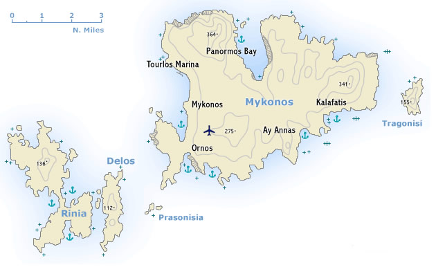
Μύκονος was once one of the most important trading centres in the western Aegean. Its arid and only moderately fertile soil permits only a modest development of agriculture, but its beautiful beaches have made it one of the most popular holiday islands in the Aegean. Indeed, the new marina port is growing in popularity and is actually becoming a small charter base from which you can hire charter yachts to start your sailing holiday. Moreover, it has a flourishing craft industry and Mykonos is also the starting point from which to visit the neighbouring island of Delos.

Δήλος, is likewise a rocky island and lies 5 nm south-west of Mykonos and it is one of the smallest of the Cyclades. Yet, Apollo was born on Delos and the island was therefore of great importance in antiquity. Indeed, the Cyclades were so called because they were seen as lying in a circle (kyklos) round this sacred island.

Mykonos and Delos

Folegandros and Sikinos

OΦολέγανδρος, between Milos and Santorini, is still barely touched by the tourist trade. The cliff-fringed eastern part of the island, with its highest hill of 413 m is bare and arid; the western half is milder, with water from springs, and supports a modest terraced agriculture. With its poverty and lack of sheltered harbours Folegandros was never an island of any importance. Its destinies were closely linked with those of Naxos and in Roman times it was a place of exile. 

Sea chart of Folegandros island

From the sailing port of Karavostasi – a must-see when sailing in Greece - it is an hour’s walk or a short trip with the only taxi on the island to the chief place, Chora, a beautiful village of typical Cycladic houses with a medieval Kastro.

Folegandros and Sikinos

Santorini

Σαντορίνη by sea, usually entering the caldera from the north-west, is the apogee of many yacht charter holidays in the Cyclades.

Sea chart of Santorini island
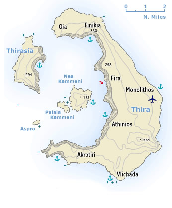
Thira together with the smaller islands of Thirasia and Aspro are part of a volcanic crater, which has been engulfed by the sea. In the centre are the Kameni - Καμένη islets, the cones of later volcanoes which came into being in historical times. 

he steep caldera cliffs range in height between 200 m and 400 m, while on the outside the land falls away gradually to the sea, its fertile slopes covered with vineyards.

Yet, the island is treeless due to lack of water, though the inhabitants achieve a modest degree of prosperity through the export of wine, pulses, pistachios and tomato purée. Santorini also possesses a natural resource in the form of pozzolana, a hydraulic cement used in structures exposed to water (harbour works, the Suez Canal).

In more recent years large numbers of visitors have been attracted to the island by its extraordinary natural structure and its excavation sites, which are among the most important in Greece, and the tourist trade has made an increasing contribution to the economy. Also – with the new Vlichada marina nearly finished (see the bottom of this page) – more and more yachtsmen visit this beautiful island.

Santorini

Amorgos

Sea chart of Amorgos islandΑμοργός is spectacular island of bare rocky hills 33 km long and up to 6.5 km wide. For the most part the south-east coast falls steeply down to the sea, but the north-west coast is gentler, with two deep inlets – the sheltered Katapola bay and Aegiali bay and several coves like Fjord cove, Kalofana bay and Akrotiri bay proofing that Amorgos should be included in itineraries on a sailing holiday. The population – much reduced by emigration – lives by farming and fishing. Ferries are not frequent, which explains the surprising low numbers of tourists. 

The remains of several ancient cities, extensive cemetery areas, finds of coins and rock inscriptions bear witness to the importance of the island in Minoan and Hellenistic times as a port of call on the sea route between Milos and the south-eastern Aegean. Used in Roman times as a place of exile and in subsequent centuries frequently harried by pirates, Amorgos has remained since then an island of no economic or political importance and has in consequence retained much of its distinctive character. 

Amorgos

Andros and Tinos

Sea chart of Andros islandΆνδρος, the most northerly and, after Naxos, the largest of the Cyclades, is a kind of south-easterly continuation of Evvia, from which it is separated by a busy and sometimes stormy channel only 8 nm wide.

In the island’s four ranges of hills, the largest of which is Mount Petalon (997 m), are marble quarries which were already being worked in antiquity. Thanks to its unusual abundance of water Andros – most Cycladic islands are rather barren – has a flourishing agriculture.

Τήνος with its highest peak Mount Tsiknias (713 m), at the east end of the island. The inhabitants live by farming on terraced fields. Characteristic features of the landscape are the Venetian-style tower-like dovecots, of which there are some 1300. There are also numerous windmills.

Andros and Tinos

Naxos

Sea chart of Naxos island
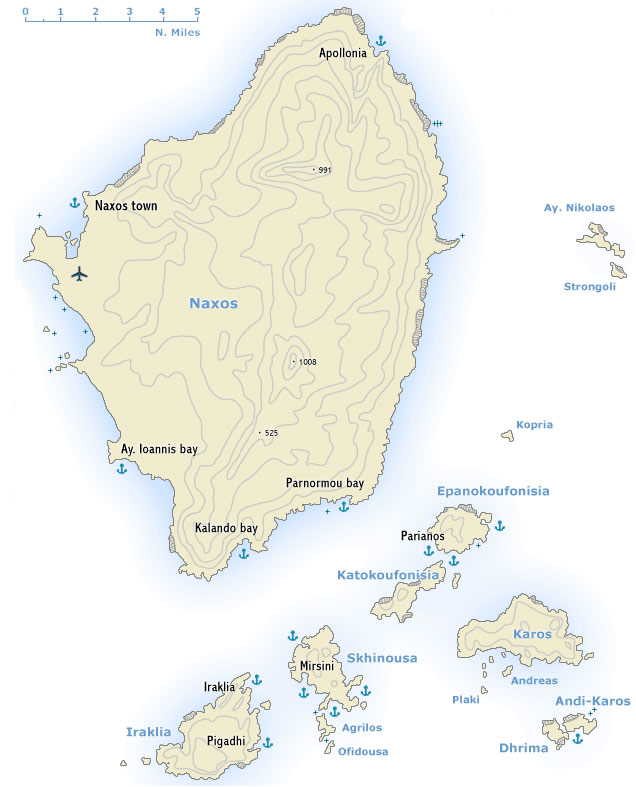
The largest and one of the most beautiful of the Cyclades, Naxos - Νάξος, is traversed from north to south by a range of hills which fall away steeply on the east but slope down gradually on the west into fertile rolling country and well-watered plains. The hills rise to a height of 1008 m and are cut by two passes. 

Since ancient times the economy of the island has depended on agriculture, marble-quarrying, emery-mining and the recovery of salt from the sea, occupations which have brought it a considerable degree of prosperity. In recent years the tourist trade has been an additional source of revenue. 

The island is not very equipped to cope with mass tourism, but it has much to offer visiting those on a sailing holiday - an equable climate, a wide variety of scenery, from the sandy anchorages of the west coast and monuments of both antiquity and medieval periods. 

Naxos

Paros and Antiparos

Sea chart of Paros islandΠάρος, lying some 8 km west of Naxos, is occupied by a range of hills of gently rounded contours, rising to 764 m in Mount Profitis Ilias (rewarding climb, with guide; magnificent panoramic views). Three bays cut deep inland – in the west the sheltered Paroikia Bay, with the island’s capital that serves as the main sailing port and as a yacht charter base; in the north the bay which shelters the little town of Naoussa, which in Roman times was the island’s main port for the shipment of Lychnites marble; and in the east the flat Marmara bay. The whole island is covered with a layer of coarse-grained crystalline limestone, in which lie rich beds of pure marble.

The island’s considerable prosperity has depended since ancient times on agriculture, favoured by fertile soil and an abundance of water, and on the working on marble, which is still quarried on a small scale. In recent years the rapid development of the tourist trade has brought changes in the landscape, the island’s economy and its social structure. 

Paros and Antiparos

Syros

Sea chart of Syros islandΣύρος lies half-way between Kythnos and Mykonos. Its central situation makes it the principal centre of administration, commerce and fisheries in the Cyclades and a focal point of the shipping routes in the Central Aegean. 

Agriculture makes a major con­tribution to the island’s economy, supplemented in the last ten years by a rapidly developing tourist trade. Both Ermoupolis and Finikas serve as practical yacht charter bases in the middle of the Cyclades, just like the Paroikia port on Paros. 
Indeed, for a sailing holiday there are several good bays to anchor: Varis in the south and Delfino, Megas Lakkos & Kini along the west coast. Moreover, the island of Gaidaros too has an excellent anchorage. 

Syros

Milos and Kimolos

Sea chart of Milos islandΜήλος, the most westerly of the larger Cyclades, owes its distinctive topography and the pattern of its economy to its origin as the caldera of a volcano of the Pliocene period, to which the sulphurous hot springs in the north-east and south-east of the island still bear witness.  It has one of the best harbours in the Mediterranean, formed when the sea broke into the crater through a gap on its north-west side. The north-eastern half of the island is flatter and more fertile than the upland region in the south-west, which rises to 752 m in Mount Profitis Ilias. The island’s principal sources of income – besides the tourists either on a sailing holiday or island hopping by ferry – are its rich mineral resources, including pumice, alum, sulphur and clay.

Kimolos - Κίμωλος is an arid and inhospitable island of volcanic origin lying, which was known in antiquity for its terra kimolia (cimolith), used both as a detergent and in medical baths.
The chief place on the island, Kimolos, lies near the sheltered port of Psathi, round the remains of the late medieval settlement of Kastro. On the island’s highest point is the ruined medieval Castle of Palaiokastro. 

Milos and Kimolos

Sifnos

Sea chart of Sifnos islandΣίφνος lies approximately in the middle of the triangle formed by Milos, Serifos and Paros. The north and north-west of the island are occupied by barren ranges of hills, the east and south by gentler uplands. The coast is much indented and lined by cliffs for much of its length.

Agriculture (particular onion-growing) on the island’s fertile soil, the manufacture of pottery of traditional type and weaving bring the inhabitants a modest degree of prosperity.

The principal port on Sifnos is Kamares, which is well sheltered, and where you can rent bikes or scooters to reach Apollonia, the island’s capital. From there roads leads to the must-see places along the coasts and indeed these also proof beautiful anchorages and should really if possible visited by boat.
The medieval village of Kastro – with remnants of its ancient walls – but also the bays of Faros, Vathi and Platis Gialos are absolutely worth exploring: translucent turquoise water, combined with good tavernas. However, the best restaurants (notably To Liotrivi) can be found in Apollonia.

Sifnos

Serifos

Σέριφος, north-west of Sifnos, is a bare and rocky island, its hills slashed by gorges; its highest point is Mount Tourlos with 483 m.

Sea chart of Serifos island
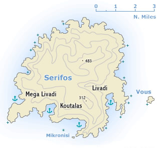
The island’s main sources of income are its modest agriculture and its open-cast iron mines, which have been worked since ancient times. The ore used to be shipped from Koutalas on the south coast, where there is now room to anchor (magnetic anomalies are reported due to the remaining ore!).

In the season especially Livadi is much frequented by charter yachts; the Chora, towering above the sheltered harbour of Livadi, makes this one of the most stunning approaches in the Northern Cyclades.

Serifos

Kythnos

Sea chart of Kythnos islandΚύθνος lies south-east of Kea and is a rocky and barren island of karstic limestone, that is usually covered in an abundance of colourful flowers in the early months of the sailing season. 

The coast is much indented – with many beautiful anchorages and ports – and for the most part falls steeply down to the sea. The inhabitants live by farming and fishing. In antiquity iron was mined on the island.

The two main ports are Mericha and Loutra. Mericha – only minutes sailing away from the oddly shaped Sandbar Bay – is the smaller of the two. Loutra on the north-east nowadays even has a new harbour with new moles providing the best protection from the Meltemi on the island. The mineral baths after which the port took its name, are unfortunately no longer in use. The mineral springs were already frequented in Roman times and can still be seen as (covered) streams that flow towards the port. 

Kythnos

Kea

Sea chart of Kea islandΚέα or Tzia - Τζια, the most westerly of the larger Cyclades, lies some 12 nm south-east of Cape Sounion. The island’s agriculture and the traditional harvesting of acorns for use in tanning have declined as a result of emigration. There is a certain amount of tourist traffic from the Greek mainland. 

On the south side of Nikolaos Bay – which was a pirate stronghold in the 13th c. – is the little port of Korissia (also known as Livadi), built on the side of ancient Koressia. There are remains of the ancient town walls and a Sanctuary of Apollo. The Kouros (statue of a youth) of Kea (530 BCE) which was found here is now in the National Archaeological Museum in Athens.
North of Korissia, at the seaside resort of Vourkari, stands the little Church of St Irini, amid the remains of a strongly fortified ancient city (3rd millenium BCE – 3rd c. AD), including the oldest temple found in Greece. (15th c. BCE).

The famous lion – carved from the native rock in the 6th c. BCE – can be seen just north-east of Kea town. And another highlight is the beautiful anchorage of Poleis.

Kea

Spetses

Sea chart of Spetses islandΣπέτσες, the ancient Pityousa (Island of Pines), is a hilly and well-wooded island off the south-west coast of the Argolida. The income of the inhabitants, who are mostly of Albanian descent, comes from farming and now, to an even greater extent, from the tourist trade, for the island’s mild climate attracts large numbers of holiday-makers.  This mild climate is described by the Admiralty pilot to be “exceedingly healthy” and is indeed more appealing than Hydra or Dokos. No motor vehicles are allowed on Spetses apart from public service vehicles.
In antiquity Spetses was an island of no importance. After the Orlov Rising, a rebellion against the Turks supported by Catherine of Great Russia, the population was expelled from the island in 1770 and Spetses town was laid waste. The inhabitants soon returned to their island, however, and their trading and seafaring activities brought them prosperity. In 1821 Spetsai was the first island to take part in the War of Independence: an event commemorated every year by ceremonies in the Madonna Armada Chapel in Ayia Marina.

Spetses

Hydra

Sea chart of Ermioni marina on Hydra island
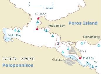
The Hydra gulf lies between the saronic gulf and the argolic gulf and is a one of the most popular yacht charter areas in Greece. The island of Hydra - Ύδρα (ancient Hydraea) itself is a bare monolithic ridge of limestone, 12 km long by 5 km wide, lying off the south-east coast of the Argolid. Arid and infertile, it lives mainly from the tourist trade and the sale of craft products (jewellery, pottery, embroidery, hand-woven cloth, leather-work). A tempting local speciality is the almond cake called amygdalote.
North-west of Hydra is the little grazing island of Dokos (the ancient Aperopia), with the village of the same name in a sheltered bay on the north coast. The mainland (in fact the Peloponnese peninsula) features many interesting anchorages and the handsome village of Ermioni. 

Hydra

Poros

Sea chart of Aegina island and Peloponnesian peninsula Πόρος, the ancient Kalureia, lies south-west of the Methana Peninsula, separated from the north coast of the Argolid by a strait between 250 m and 1000 m wide, 1.5 km long and up to 4 meters deep.  Most of the island is covered with thin woodland and macchia. The inhabitants, many of whom are of Albanian descent, live by farming the fertile coastal areas on the mainland which belong to Poros and, increasingly, by the tourist trade. There was a settlement in Mycenaean times on the site later occupied by the Sanctuary of Poseidon. The ancient city was abandoned after the Roman period, and the modern town was established only in the late Middle Ages. 

Poros

Aegina

Sea chart of Aegina island Αίγινα, lying some 17 nm south-west of Piraeus, is a hilly and fertile island of Tertiary limestones and schists, with isolated rounded hills of volcanic origin. For the most part the coast falls steeply down to the sea, with few sheltered bays. The main occupation of the inhabitants is farming, in particular the growing and export of the island’s excellent pistachio nuts. Fishing, sponge-diving and pottery manufacture are also of some economic importance. Aegina is noted for the production of its water-coolers (kannatia) – two-handled wide-necked jars in a porous fabric which keep their contents cool by evaporation. With its mild climate and low rainfall, Aegina has long been favoured as a summer resort by the prosperous citizens of Athens. In recent years it has become increasingly popular with foreign visitors.

Aegina

Suggested routes

Route H

The Saronic and Argolic gulf

Two weeks starting and ending in Athens.

  1. Alimos 
  2. Aegina 
  3. Hydra 
  4. A day for rest, sightseeing and recreation. 
  5. Spetses 
  6. Kiparisi 
  7. Gerakas 
  8. Monemvassia 
  9. A day for rest, sightseeing and recreation. 
  10. Ermioni 
  11. Poros 
  12. Methana 
  13. Epidavros 
  14. Alimos 

Route B

The Cyclades

One week starting and ending in Athens.

  1. Alimos 
  2. Kythnos Mericha 
  3. Syros Ermoupolis 
  4. Mykonos Delos 
  5. Kea 
  6. Sounion 
  7. Alimos 

Route L

The Cyclades

Three weeks starting and ending in Athens.

  1. Alimos 
  2. Kea 
  3. Syros Ermoupolis 
  4. Paros Naoussa 
  5. Paros Paroikia 
  6. Andiparos 
  7. A day for rest, sightseeing and recreation.  
  8. Ios 
  9. Santorini 
  10. A day for rest, sightseeing and recreation.
  11. Amorgos 
  12. Sikinos 
  13. Folegandros 
  14. Polyaigos 
  15. Milos 
  16. Sifnos Kamares 
  17. A day for rest, sightseeing and recreation.
  18. Serifos 
  19. Kythnos Mericha 
  20. Sounion 
  21. Alimos 

Weather forecasts are a sailor's best mate

Planning your next maritime adventure? Don't embark without your secret weapon – the weather forecast! Accurate weather predictions aren't just about rain or shine; they're your compass for smooth sailing. From wind strength to potential storms, these forecasts are your nautical crystal ball. Stay ahead of the elements and chart a course for success. Trust the forecast, and let your next voyage be a tale of triumph, not turbulence. Fair winds and following seas await those who navigate wisely!

About us

Aegean Sails as an established family business at the field of yachting, since 2013 we continue our successful presence and strive for the top quality yachting services.

A big part of our company essence is that we try to think like customers and we care about making friends that enjoy sailing rather than clients and immediate and personal support.

Email:
Phone:
+30 697 6692528
Facebook:
Aegeansailsvg