Sea chart of Kythnos islandΚύθνος lies south-east of Kea and is a rocky and barren island of karstic limestone, that is usually covered in an abundance of colourful flowers in the early months of the sailing season. 

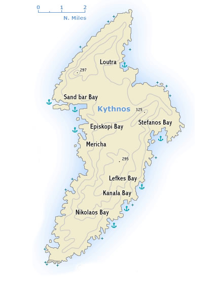
The coast is much indented – with many beautiful anchorages and ports – and for the most part falls steeply down to the sea. The inhabitants live by farming and fishing. In antiquity iron was mined on the island.

The two main ports are Mericha and Loutra. Mericha – only minutes sailing away from the oddly shaped Sandbar Bay – is the smaller of the two. Loutra on the north-east nowadays even has a new harbour with new moles providing the best protection from the Meltemi on the island. The mineral baths after which the port took its name, are unfortunately no longer in use. The mineral springs were already frequented in Roman times and can still be seen as (covered) streams that flow towards the port. 

The anchorages in Stefanos Bay are also worth visiting.

The two charming inland villages, Chora (Kythnos town) and the lively little Dryopis, can best be visited by scooter or bike.

The first settlers were Dryopes from Evvia, who were later driven out by Ionians. Kythnos never played any important part in history. 

To the north of Mericha, on a high crag above the bays of Apokrousis and Episkopi, are the ruins of the Kythnos’ former capital, Vryokastro (Evraiokastro). On the rocky offshore island in Sandbar Bay, originally connected properly with the mainland, traces of the agora and of a number of tombs in the surrounding area can still be identified. 


Suggested routes

Route E

The Saronic and Argolic gulf

One week starting and ending in Athens.

  1. Alimos
  2. Hydra 
  3. Navplio 
  4. Drepano 
  5. Spetses 
  6. Poros 
  7. Alimos 

Route J

The Saronic and Argolic gulf

Two weeks starting and ending in Lavrion.

  1. Lavrion 
  2. Kea 
  3. Kythnos 
  4. Hydra 
  5. A day for rest, sightseeing and recreation. 
  6. Kiparisi 
  7. Leonidio 
  8. Spetses
  9. A day for rest, sightseeing and recreation. 
  10. Poros 
  11. Methana 
  12. Aegina 
  13. Sounion 
  14. Lavrion 

Route K

The Saronic and Argolic gulf

Three weeks starting and ending in Athens.

  1. Alimos 
  2. Methana 
  3. Poros 
  4. Spetses 
  5. Monemvasia 
  6. A day for rest, sightseeing and recreation. 
  7. Elafonisos 
  8. Plitra 
  9. Kithera
  10. A day for rest, sightseeing and recreation. 
  11. Gerakas 
  12. Kiparisi 
  13. Leonidio 
  14. Astros 
  15. Navplio 
  16. A day for rest, sightseeing and recreation. 
  17. Tolo 
  18. Drepano 
  19. Hydra 
  20. Aegina 
  21. Alimos 

Weather forecasts are a sailor's best mate

Planning your next maritime adventure? Don't embark without your secret weapon – the weather forecast! Accurate weather predictions aren't just about rain or shine; they're your compass for smooth sailing. From wind strength to potential storms, these forecasts are your nautical crystal ball. Stay ahead of the elements and chart a course for success. Trust the forecast, and let your next voyage be a tale of triumph, not turbulence. Fair winds and following seas await those who navigate wisely!

About us

Aegean Sails as an established family business at the field of yachting, since 2013 we continue our successful presence and strive for the top quality yachting services.

A big part of our company essence is that we try to think like customers and we care about making friends that enjoy sailing rather than clients and immediate and personal support.

Email:
Phone:
+30 697 6692528
Facebook:
Aegeansailsvg