Kea
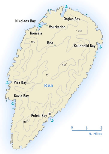 Κέα or Tzia - Τζια, the most westerly of the larger Cyclades, lies some 12 nm south-east of Cape Sounion. The island’s agriculture and the traditional harvesting of acorns for use in tanning have declined as a result of emigration. There is a certain amount of tourist traffic from the Greek mainland.
On the south side of Nikolaos Bay – which was a pirate stronghold in the 13th c. – is the little port of Korissia (also known as Livadi), built on the side of ancient Koressia. There are remains of the ancient town walls and a Sanctuary of Apollo. The Kouros (statue of a youth) of Kea (530 BCE) which was found here is now in the National Archaeological Museum in Athens.
North of Korissia, at the seaside resort of Vourkari, stands the little Church of St Irini, amid the remains of a strongly fortified ancient city (3rd millenium BCE – 3rd c. AD), including the oldest temple found in Greece. (15th c. BCE).
The famous lion – carved from the native rock in the 6th c. BCE – can be seen just north-east of Kea town. And another highlight is the beautiful anchorage of Poleis.
Kea
Santorini
Σαντορίνη by sea, usually entering the caldera from the north-west, is the apogee of many yacht charter holidays in the Cyclades.
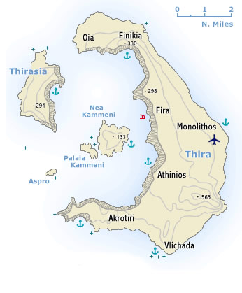 Thira together with the smaller islands of Thirasia and Aspro are part of a volcanic crater, which has been engulfed by the sea. In the centre are the Kameni - Καμένη islets, the cones of later volcanoes which came into being in historical times.
he steep caldera cliffs range in height between 200 m and 400 m, while on the outside the land falls away gradually to the sea, its fertile slopes covered with vineyards.
Yet, the island is treeless due to lack of water, though the inhabitants achieve a modest degree of prosperity through the export of wine, pulses, pistachios and tomato purée. Santorini also possesses a natural resource in the form of pozzolana, a hydraulic cement used in structures exposed to water (harbour works, the Suez Canal).
In more recent years large numbers of visitors have been attracted to the island by its extraordinary natural structure and its excavation sites, which are among the most important in Greece, and the tourist trade has made an increasing contribution to the economy. Also – with the new Vlichada marina nearly finished (see the bottom of this page) – more and more yachtsmen visit this beautiful island.
Santorini


